ALBANY, NY –
Governor Kathy Hochul declared a State of Emergency for eight counties across southern New York earlier today, October 12, urging New Yorkers to continue to prepare as a strong coastal storm is set to impact much of New York beginning Sunday afternoon. The State of Emergency applies to the Bronx, Kings, Nassau, New York, Queens, Richmond, Suffolk and Westchester Counties as well as counties contiguous to those eight.
New York State has been working in close coordination with all county and city partners on storm preparations including the City of New York, a press release by the Governor’s Office states.
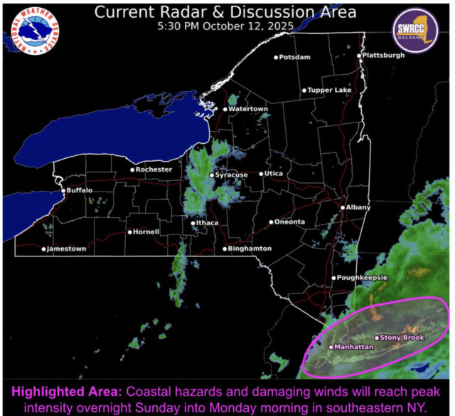
The storm has strengthened as it has moved up the mid-Atlantic coast toward southern New England and is expected to cause widespread moderate to major coastal flooding throughout Downstate New York, along with bringing strong winds and long duration rain to the region.
In response, utilities have added more than 1,600 workers throughout the Mid-Hudson, New York City and Long Island Regions to support storm response operations.
“As the Nor’easter continues making its way through New York, I’m declaring a State of Emergency across boroughs and counties most impacted by the storm”, Governor Hochul said. “The safety of New Yorkers is my top priority, and I continue to urge extreme caution until the storm has passed through the state”.
Governor Hochul began warning New Yorkers of this storm and its impacts earlier this week and is continuing to urge New Yorkers to closely monitor their local forecasts, prepare their households accordingly and avoid traveling in impacted areas this weekend.
According to the Governor’s Office:
New York State Department of Public Service staff have been in communication with the electric utilities with service territories in the forecasted area anticipated to be affected by this weekend’s Nor’easter event. Con Edison, Orange and Rockland, PSEG Long Island, Central Hudson Gas and Electric, and NYSEG are all actively monitoring forecasts and preparing for potential impacts to their respective service territories.
Utility preparations have included bringing in an additional 1,618 workers, activation of respective Incident Command, staging equipment, conducting outbound calls to Life Support Equipment (LSE) customers and critical facility customers in the areas anticipated to receive the most impacts, as well as conducting municipal officials calls. Utility crews are prepared to operate in the overnight hours to respond where safe to do so. All utilities continue to monitor the forecast and will make resource adjustments in alignment with existing emergency plans.
The utilities have approximately 7,118 workers available statewide to engage in damage assessment, response, repair, and restoration efforts across the state, as necessary. This includes the addition of more than 1,600 workers since Friday, with ConEd and Orange and Rockland adding 900 workers, PSEG LI adding 520, and NYSEG adding 198 workers, and Central Hudson adding 44 workers. Department staff will track utilities’ work throughout the event and ensure utilities shift appropriate staffing to regions that experience the greatest impact.
The threat for coastal flooding has increased as the storm has moved up the coast and the National Weather Service now has Coastal Flood Warnings in place for Long Island, New York City and Southern Westchester County beginning 12 p.m. Sunday through 8 p.m. Monday. Forecasts are calling for widespread moderate to major coastal flooding for the south shore bays of Nassau and southwestern Suffolk counties during times of high tide until Monday. Widespread minor to moderate coastal flooding remains a threat for the remainder of the coastline, with the widespread possibility of dune erosion and localized overwashes along the Atlantic Ocean beaches.
Strong winds are also expected to be a major hazard throughout the duration of the storm. The National Weather Service has issued a High Wind Warning for much of Suffolk County beginning at 12 p.m. Sunday through 6 p.m. Monday, with a Wind Advisory in place for the rest of Long Island, New York City and Southern Westchester County. During this period, wind gusts of up to 60 miles per hour are possible and could result in downed trees and possible power outages. Due to the forecasted high wind conditions, MTA Bridges and Tunnels will implement a ban on empty tractor-trailers and tandem (piggyback, dual, triple, etc.) trucks on its seven bridges beginning 3:00 p.m. Sunday. Based on the current forecast and the overall timing of this weather event, it is anticipated this ban will be in place until 6:00 p.m. Monday.
Forecasters are also calling for long duration rainfall as part of this storm, the most intense of which will be focused downstate where between 1.5 and 3 inches of rainfall is expected in the lower Mid-Hudson, New York City and Long Island Regions and minor flooding resulting from poor drainage is possible. The northern Mid-Hudson and southern Capital Regions are forecast to receive between an inch and 1.5 inches of rain, while the rest of the state should see an inch or less. The rainfall has the potential to cause flooding in urban areas with poor drainage throughout Sunday and into Monday.
New Yorkers are encouraged to monitor their local forecasts, weather watches and warnings. It is critical to ensure that government emergency alerts are enabled on their mobile phones. New Yorkers can also sign up for real-time weather and emergency alerts that will be texted to their phones by texting their county or borough name to 333111. For a complete listing of weather alerts, visit the National Weather Service website at alerts.weather.gov.


